Railroadforums.com is a free online
Railroad Discussion Forum and
Railroad Photo Gallery for railroaders, railfans, model railroaders and anyone else who is interested in railroads. We cover a wide variety of topics, including freight trains, passenger and commuter railroads, rail news and information, tourist railroads, railway museums and railroad history.
Vancouver: New signals N & S of station, excavation for east side bypass track, new platform east of station and Hill St., trench work under bridge ongoing.
As of a week or so ago, no sign of a bridge for the new turntable pit (looks longer than the old one). New building erected just south of the 39th St. bridge.
Newspaper said the truss bridge over the Washougal River in Camas is to be replaced, but I haven't checked on it.
Bruce
Busy on the Bellingham Sub. More concrete ties and updated crossings. During the daytime work window the empty coals are going down the Sumas line. I guess they figured out the 6 axle curvature problem in Sedro Woolley. Read in the local paper that two new sidings are planned, one to the immediate south of Ferndale and one to the north of town.
It's strange to see the rather short ballast trains are powered by a pair of Dash 9's. For a short time a pair of SD70's were part of the maintenance roster. I guess the days of GP-30's and GP-9's are over.

It's strange to see the rather short ballast trains are powered by a pair of Dash 9's.
Ballast loads are pretty heavy and the Bellingham Sub does have grades where they've been doing the tie work.
I drove through Camas a couple of days ago. There was a glimpse of something through the trees that could be new roadbed west of the paper mill. There was no apparent activity around the Washougal river bridge.
Bruce
I had a few minutes today for some Vancouver photos.
New Columbia River Bridge and Vancouver Center signals
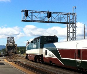
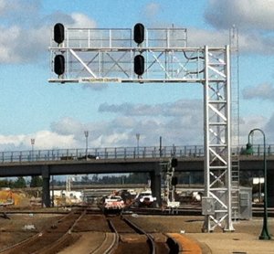
New passenger platform east of Hill street. This may prevent the Empire Builder from blocking Hill St., but looks a little short for that. The sharper curved part goes along with a newspaper article that the tracks were being moved north to allow higher speeds. This didn't make sense to me as it would be a sharper curve. All I can think of is it would allow for higher speed switches coming off the bridge northbound to eastbound. Can anyone verify?
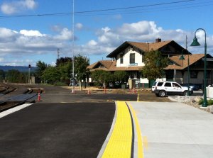
Bruce
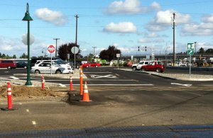
New parking lot at the station. Hill Street now looks like a street instead of a parking lot. The gas facility how has blocks and a fence to separate it from the parking lot.
Bruce
I had a few minutes today for some Vancouver photos.
New Columbia River Bridge and Vancouver Center signals
View attachment 129731 View attachment 129732
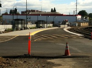
New passenger platform east of Hill street. This may prevent the Empire Builder from blocking Hill St., but looks a little short for that. The sharper curved part goes along with a newspaper article that the tracks were being moved north to allow higher speeds. This didn't make sense to me as it would be a sharper curve. All I can think of is it would allow for higher speed switches coming off the bridge northbound to eastbound. Can anyone verify?
View attachment 129733 View attachment 129734
Bruce
Yes. Speeds are to go up to 25 MPH from the current 10 MPH. The curves will be broader hence the curve looks like it should have a longer radius where the shelters are. The blacktop is temporary just like we have at Auburn, WA on the west side platform where a new Main 1 will be built next year and the temporary asphalt will be removed. The yellow lines are the ADA bumpy rubber strips used on all passenger platforms to warn people from walking off the platform onto the track if they are vision impaired. Nice shots. I haven't made it down this year yet. I was waiting until the new curves were installed. Also, moving the track north would make it go right through the current platform next to the station another reason to move the platform eastward.
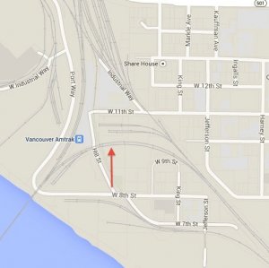
Seems to me if the track is moved north at the red arrow, the curve would have to be sharper, not broader, at that point.
Bruce
I'm hearing that grading is in progress at Pioneer in preparation for the 2015 US Open. Also heard that grading has begun in Burlington at the north end of the yard for the oil trains running in and out of the Anacortes Spur.
Saturday there was a loaded ribbon-rail train at Gold Bar, where is the new rail going?
-KristopherJ
Saturday there was a loaded ribbon-rail train at Gold Bar, where is the new rail going?
That's probably rail for Stevens Pass. Steel gangs will work from Wenatchee going west soon.
Looks like a new crossover is being built in Kalama. A new cantilever signal is going up just north of the Temco grain elevator.
The Anacortes Spur of the Bellingham Sub will be getting nearly 15,000 ties at years end.
The Anacortes Spur of the Bellingham Sub will be getting nearly 15,000 ties at years end.
I assume this is due to the increase in oil tank trains. Any work being done on the roadbed?
Wonder what sort of work was done at the Anacortes refinery to handle this huge surge in tank cars? I seem to recall talk a little while back about laying heavier rails on the spur, but surely a major overhaul of the entire line is called for! Apparently traffic is only going to increase in the foreseeable future.
Curious too about the unloading procedures; are the tanks 'washed' internally to extract the last few drops, and does the Bakken crude's notorious gassyness cause a pressure buildup or otherwise complicate handling?
For a person from South Australia, what part of Washington State are you referring to please?
Mike
The northern part of Puget Sound, east from Victoria, British Columbia. Query Anacortes, Washington via Google or Map Quest and you should find it.
As far as I can tell, they did overhaul the track with heavier CWR of 136# some time earlier. No idea of the unloading procedures.
Seems to me if the track is moved north at the red arrow, the curve would have to be sharper, not broader, at that point.
Bruce
View attachment 129737
It's all about the radius. You need more height on your diagram to allow it to stretch outward. I don't believe that picture is exactly to scale. They'll start with a higher number switch at the bridge such as , per my plans, two #15s switches, then curve it more gently toward the new station platform and push it out toward the east end of 8th street. My plans show that the most restrictive part of the curve is near the bridge so the part near 8th street already has a large enough radius curve and doesn't need moving until you're westward about 1/4 way around the curve from 8th street. That's the best I've got for an explanation.
Looks like a new crossover is being built in Kalama. A new cantilever signal is going up just north of the Temco grain elevator.
They have an Interstate South. I thought the Interstate North could be up near the old MP 111 say about 111.6 or so. This would also open up the opportunity to install storage tracks between the two Interstates for grain train staging both empty and loaded. Up north of Kalama, I just looked up the new third mainline project which will start near the bridge over the Kalama River, at that point, and go south. How wide is the cantilever signal bridge and is it for southbound control signals? The third main construction is not suppose to happen until next summer, but having a new high speed crossover there would be necessary to get the full use of three mains and having a two track cantilever signal bridge there for southbound movement could be the starting point of the project but under the guidelines of the work already approved for Signal and Track Improvements South with the federal money. They may call the crossover CP Kalama... perhaps.
RailroadForums.com is a participant in the Amazon Services LLC Associates Program, an affiliate advertising program designed to provide a means for sites to earn advertising fees by advertising and linking to amazon.com
RailroadBookstore.com - An online railroad bookstore featuring a curated selection of new and used railroad books. Railroad pictorials, railroad history, steam locomotives, passenger trains, modern railroading. Hundreds of titles available, most at discount prices! We also have a video and children's book section.
ModelRailroadBookstore.com - An online model railroad bookstore featuring a curated selection of new and used books. Layout design, track plans, scenery and structure building, wiring, DCC, Tinplate, Toy Trains, Price Guides and more.
|
Affiliate Disclosure: We may receive a commision from some of the links and ads shown on this website
(Learn More Here)


